

Geocoding
Identifying current customer locations for marketing and demographic purposes
Problem and Objective
Many businesses collect address information from their customers that can later be used for marketing and demographic purposes. To perform analysis on this information, these addresses need to be geocoded and placed on a map. The objective is to use this address data to place a company’s current customers on a map and display them for the company.
Analysis Procedures
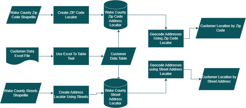
To complete the objectives of this assignment, I used ESRI ArcGIS Pro 2.9.5 and various geocoding tools from the toolboxes included in ArcGIS Pro. The geocoding tools used were the Create Locator tool, Geocode Addresses, and the Rematch Addresses tool. The data used for this process was an Excel spreadsheet with current customer address data provided by the instructor, vector shapefiles of the boundaries of Wake County and the boundaries of zip codes inside Wake County and a shapefile of Wake County streets.
The first objective was to geocode customer data by Zip Code and visualize this in a map. Customer data was provided to us in an Excel table. First, I added the customer data to the map using the Excel to Table tool and reviewed the attribute table for the created file to ensure accuracy. Next, I created a locator using the Create Locator tool in ArcGIS. This locator was set up to use Zip Codes to locate customer points to polygons on the map.
Due to some errors in the Zip Code feature layer, the Repair Geometry tool was run to resolve these. After creating the locator, I used the Geocode Addresses tool using the previously created locator and matching it with the customer data. Due to their being some polygons in the Zip Code feature class with the same Zip Code attribute and also some errors in the customer data, I ran the Rematch Features tool to correctly identify which polygons these customers belong to and fixed any errors.
After determining that these results would not be sufficient for market analysis, I decided to run a similar process again but using Street Addresses to locate instead of Zip Codes. A locator was created using the Streets in Wake County feature class and was tested for accuracy. Next, geocoding was performed again with this newly created locator and using the street addresses of customers as opposed to zip codes for more accurate placement on the map. The Rematch tool was run again and errors were corrected in the data. Next, maps were created for both the customers geocoded by Zip Codes and customers geocoded by Street Addresses.
Results


Application & Reflection
Many times the data we need to visualize isn’t always already in a vector data format and ready to use in your preferred map making software. Geocoding is an incredibly useful tool that is applicable in many different fields, including conservation management (like the scenario described below).
Problem description
A beekeeper wants to start a new apiary in Wake County, North Carolina but wants to make sure it is at least 3 miles away from other existing apiaries to prevent hive robbing events. They would also like to take into account land cover data and hydrography data to ensure the apiary is placed near a fresh water source and has abundant food sources.
Data needed
The addresses of current apiaries from BeeCheck.org as well as county boundaries and other relevant features such as streams and land cover data.
Analysis procedures
I would first obtain the addresses of all current apiaries within Wake County from BeeCheck.org, which allows other beekeepers to upload the addresses of their hives. I would then geocode these addresses and display them on a map. I would then create a buffer zone of 3 miles around each apiary, and then delete the buffer zones from the county boundary shapefile, thus leaving only areas that are a safe distance away from other apiaries.
I would then buffer a certain amount from streams and lakes, and select the most desirable land cover classifications to display. Finally I would intersect all of these layers, leaving me with a map that only shows the most suitable locations for a new apiary within Wake County.